 Mikhaylovka
  Dyrestuy
  Mikhaylovka
  Mayskiy
  Novobessergenevka
  Tersky District
  Lesnoy
  Tertezh
  Kuz'minskiye Otverzhki
Vodnyj, park kultury i otdyha on the map, Novokuznetsk, Russian Federation
Photo

Where is located Vodnyj, park kultury i otdyha
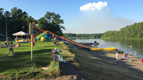
Vodnyj, park kultury i otdyha — local attraction, which is located at Volokolamskaya Ulitsa, 80/13, Novokuznetsk, Kemerovo Oblast, 654066 and belongs to the category — park. Average visitor rating for this place — 4.1 (according to 953 ratings, information from open sources and relevant for 2022).
Exact location — Vodnyj, park kultury i otdyha, marked on the map with a red marker.
You can get directions to Vodnyj, park kultury i otdyha on the map from your location.
What else is interesting in Novokuznetsk? You can see all the sights if you go to the city page.
Coordinates
Vodnyj, park kultury i otdyha, Russian Federation coordinates in decimal format: latitude — 53.744910483897314, longitude — 87.18548839837842. When converted to degrees, minutes, seconds Vodnyj, park kultury i otdyha has the following coordinates: 53°44′41.68 north latitude and 87°11′7.76 east longitude.
Nearby cities
The largest cities that are located nearby:
- Prokopyevsk — 30 km
- Mezhdurechensk — 61 km
- Leninsk-Kuznetskiy — 117 km
- Biysk — 187 km
- Barnaul — 226 km
- Abakan — 281 km
- Novosibirsk — 299 km
- Tomsk — 330 km
- Seversk — 343 km
- Achinsk — 345 km
- Krasnoyarsk — 435 km
- Rubtsovsk — 477 km
- Oskemen
(Kazakhstan) — 528 km
- Kyzyl — 550 km
- Kansk — 594 km
- Semey
(Kazakhstan) — 609 km
- Altay
(China) — 658 km
- Pavlodar
(Kazakhstan) — 706 km
- Ekibastuz
(Kazakhstan) — 839 km
Distance to the capital
Distance to the capital (Moscow) is about — 3121 km.
