
 Gilserberg
Berlin
Bordesholm
Bechtolsheim
Aub
Triptis
Heppenheim
Biblis
Angermünde
Gilserberg
Berlin
Bordesholm
Bechtolsheim
Aub
Triptis
Heppenheim
Biblis
Angermünde
Niedtal-Radweg on the map, Beckingen, Germany
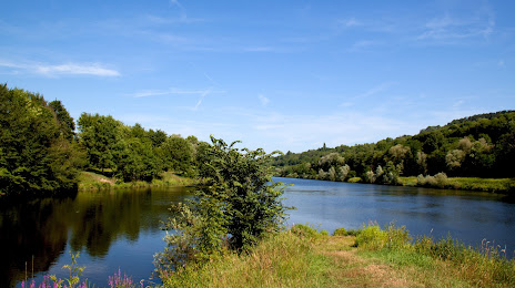
Photo
Where is located Niedtal-Radweg
Niedtal-Radweg — local attraction, which is located at 66780 Rehlingen-Siersburg, Germany and belongs to the category — tourist attraction. Average visitor rating for this place — 4.5 (according to 33 ratings, information from open sources and relevant for 2022).
Exact location — Niedtal-Radweg, marked on the map with a red marker.
You can get directions to Niedtal-Radweg on the map from your location.
What else is interesting in Beckingen? You can see all the sights if you go to the city page.
Coordinates
Niedtal-Radweg, Germany coordinates in decimal format: latitude — 49.38474045036677, longitude — 6.665726425242475. When converted to degrees, minutes, seconds Niedtal-Radweg has the following coordinates: 49°23′5.07 north latitude and 6°39′56.62 east longitude.
Nearby cities
The largest cities that are located nearby:
- Saarbrücken — 27 km
- Trier — 40 km
- Metz
 (France) — 49 km
 - Nancy (France) — 86 km
- Strasbourg (France) — 119 km
- Koblenz — 124 km
- Ludwigshafen — 125 km
- Mannheim — 127 km
- Mainz — 128 km
- Karlsruhe — 130 km
- Wiesbaden — 133 km
- Heidelberg — 142 km
- Darmstadt — 149 km
- Bonn — 151 km
- Pforzheim — 155 km
- Liège
 (Belgium) — 158 km
 - Aachen — 159 km
- Frankfurt — 161 km
- Offenbach — 166 km
Distance to the capital
Distance to the capital (Berlin) is about — 587 km.